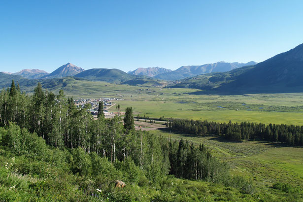
Baxter Gulch Trail Begun

View from Baxter Gulch

The beginnings of the new Baxter Gulch Trail commenced this summer with a grant from Great Outdoors Colorado funding a group from the Colorado Youth Conservation Corps to begin trailwork. About 10 youth, ages 17—22, built approximately 1/2 mile of the trail.  The trail is at an 8% grade and 24” across—perfect for mountain biking and hiking.  Dana Lambert of Arrowhead Trails oversaw the construction and provided professional trail building experience to the project.

The trail will continue to be built in stages for the next couple of years with the final stages allowing for volunteer efforts from the community. Ultimately, the trail will provide access to climbing Whetstone Mountain as well as a through trail to Ohio Creek.  A feasibility study has begun to place a campground at the trailhead.

Special thanks should be sent to Jake Jones, Town of Crested Butte Parks & Recreation Director and John Hess, Town of Crested Butte Town Planner who made this trail construction project happen

PLEASE NOTE: The Baxter Gulch Trail is NOT open and will not be for some time due to the multiple-year needs in constructing.

1% for Open Space funded the final needed trail easement to create an environmentally sound and user-friendly trail in 2010 with the Town of Crested Butte.  The Town of Crested Butte and Crested Butte Land Trust also did considerable work in acquiring easements to help make this trail happen.  Thank you to all the private land owners and organizations who have helped bring this amazing amenity to the community!


New Kikel Trail Talks

Kikel preserved acres

Discussions have begun with the Kochevar Trails Coalition with the Crested Butte Land Trust leading the charge to connect the new Lupine Trail on the Kochevar Parcel with the Kikel Parcel with a new trail.  The new trail would link the Lupine Trail through Kikel to meet the Slate River Road near the Gunsight Bridge Parcel.  This new trail would eliminate user needs to hike or bike through the current exit route of the Lupine Trail that runs down a county road and through a considerable amount of gates.  It would also provide a more direct route for connecting with the Gunsight Bridge and Lower Loop trails.  Consideration is being made to make the trail wide enough for adaptive users.

Construction on the new trail will most likely begin in the spring and summer of 2012.

1% for Open Space helped fund the Kochevar Parcel in 2010 with the Town of Crested Butte, the Kikel Parcel in 2006 with the Crested Butte Land Trust, the Gunsight Bridge Parcel with the Crested Butte Land Trust in 2002, and the Lower Loop with the Crested Butte Land Trust in 1998 and 1999.

The Kochevar Trail Coalition is a consortium of non-profits and governmental entities focused on providing open space and trail amenities to the community. The group consists of 1% for Open Space, Crested Butte Mountain Bike Association, Town of Crested Butte Planning Department, Town of Crested Butte Parks and Recreation Department, Town of Crested Butte Town Council, Crested Butte Land Trust, Gunnison County Trails Commission, Gunnison County Land Preservation Board, Elk Mountain Hikers Club, Adaptive Sports of Crested Butte and Gunnison County Commissioners


Gunsight Bridge Reclaimed

In 2002 1% for Open Space gave $50,000  to the Crested Butte Land Trust to preserve 120 acres at Gunsight Bridge.  The parcel serves as an important connector between the Lower Loop and BLM land, essentially allowing residents and visitors the opportunity to access wilderness land directly from town.  Now, nine years later, the Gunsight Bridge parcel is becoming even better.

Over 11,000 cubic yards of coal removed.  Set into the ground were 15,450 individual plants of 17 different species. Over 125 pounds of seed mix spread with species such as yarrow, paintbrush, lupine and flax.  Recovering from 40 years of hard mining that ended in 1929.

These are just some of the reclamation numbers of the Slate River wetlands on the Gunsight Bridge parcel. This 120-acre connector from the Lower Loop to BLM land was permanently preserved by the Crested Butte Land Trust (CBLT) in 2003,with a conservation easement held by the Town of Crested Butte.

Tara Tafi, Project Manager from the Colorado Division of Reclamation, Mining, and Safety (DRMS), led volunteers through the reclamation site on Saturday, October 22, after a rigorous day of planting willow, wood rose, shrubby cinqufoil and wax currant on the wetland buffer zone of the project area.  The group tiptoes through loose soil and small nuggets of coal, 11,000 wetland plugs and 30 sod patches that dot the recovering wetland like implants for a receding hairline.  Rhizomes from the plugs will spread roots and shoots from nodes underground to propagate more wetland plants.  Blue joint, reed grass, beaked sedge, water sedge, Baltic rush, tufted hairgrass and large leaf avens are all part of the optimistic mix.  Meanwhile, the surviving wetland creeps in, slowly growing over the now exposed topsoil and thin layer of coal.  Tara estimates that in five years, the plants will have won, and the wetland will once again function like the filtering system it is.

Where did the coal come from?

Tara and the DRMS, in partnership with the CBLT and the Coal Creek Watershed Coalition (CCWC), are cleaning up the mining refuse from the second largest coal mine in the Crested Butte region in the late 1800′s.  Duane Vandenbusche, author of The Gunnison Country, writes that Crested Butte father Howard Smith purchased all of Smith Hill in 1879 after turning up the prized high quality anthracite coal.  The Smith Hill Mine began operations in 1882 with a 1,628-foot tramway running from the mine on top of Smith Hill to a mammoth, 80-foot coal breaker.  The only anthracite breaker west of Pennsylvania, it crushed and sized the coal, where the Denver Rio Grand railway then hauled it away.  Standing next to a small and now uncovered stream, Tara says the coal in that spot rose to eye level. Along with the waste, they’ve also unearthed a lot of trash, including shoes and bottles from the era.  One bottle, she reports, reeked with the booze still sloshing inside.

Overview of reclamation area

The Process of Reclamation

Hauling the coal away is cost prohibitive, explains Tara.  The brand of coal in Crested Butte is low sulfur, however, so abandoned coal mines like the Smith Hill Mine are not cursed with acid mine drainage.  When so thickly layered, however, water cannot percolate up to the surface to support plant life.

The task of restoration becomes not to remove all of the coal, but to resore the pre-mining hydrology to the wetlands. Some of the coal remains as a thin veneer over the original ground surface through which places can grow.  Of the 11,000 cubic yards of coal removed from the wetland, 4,000 was blended into the hillside below the Slate River Road.  The rest was wrapped in a geo-grid material to increase its strength and prevent it from sloughing into the wetland and waterway.  Topped by road base, the area will continue to serve as a cattle load for local rancher Curtis Allen.  While the land revegetates itself, the cattle will be directed by fencing to keep them off the delicate terrain.

“The wetlands will begin to grow back in,” explains Tara, “because we have restored the hydrology.  Now the water can percolate up whereas before the coal was damming it.  Now the water can do what it wants, and do it naturally.”

The project found its seed when the DRMS and CBLT worked together on the Peanut Mine reclamation project in 2007, also a Land Trust conserved property. One-hundred percent of the half million dollars for the project came from the Abandoned Mine Reclamation Fund – a federal fund collected from severance taxes paid by coal mining companies.  The DRMS contracted wetland ecologist Andy Herb of AlpineEco to create the restoration design.  Since this past August Andy and Tara, along witha host of excavators and several days of volunteers from the Crested Butte Community School, Gunnison High School and Western State College, and CCWC have plant by plant and seed by seed been putting the wetland back together.

The Conservation of Gunsight Bridge

Restoring the wetland would never have been possible if it weren’t for the conservation efforts of the land itself by the Crested Butte Land Trust, who received the support of local funders to make the original preservation happen.

Funding the property was the Gunnison Valley Land Preservation Board with funds from Gunnison County, the City of Gunnison, Crested Butte and Mt. Crested Butte specifically designated to protect open space and agricultural heritage of Gunnison County; Great Outdoors Colorado, using a portion of lottery dollars for the protection of Colorado’s open space; and the Town of Crested Butte with  funds gathered in its 3% Real Estate Transfer Tax, half of which is designated for the preservation of open space outside the town limits.  And finally, 1% for Open Space granted money from customer donations collected by the over 70 participating businesses.  In this way, patrons of any 1% for Open Space business can feel proud to have individually contributed to the preservation, and hence restoration, of this land.

From conservation to restoration, the Gunsight Bridge parcel is one of those shining examples of a variety of organizations, volunteers, donors and community members demonstrating when we receive so much, it is also important to give back.

“The restoration project of Gunsight Bridge meets every conservation value of the Crested Butte Land Trust,” concludes Executive Director Ann Johnston, “It supports historic grazing practices, protects wildlife habitat and provides free recreation for hundreds of people. It really is a fantastic project.”

Lupine Trail Ready!

Lupine Trail worker line

Through the weekend of June 4th and 5th over 150 volunteers joined to created the new Lupine Trail on the recently purchased Kochevar Parcel. Customer contributions from participating 1% for Open Space businesses granted $110,000 to preserve this land last summer.

The weekend went fast and hundreds of Trail Fairy coupons were given out to help educate and drive customers to 1% for Open Space businesses. The more we support 1% businesses, the more money we have to protect our lands, lifestyle and viewscapes.

The trail is rideable, but some “buffing” is required. Mark your calendars for Wednesday, June 15 at 4 p.m. to fine tune the trail and earn more Trail Fairy coupons! Watch the website for meeting spots.